

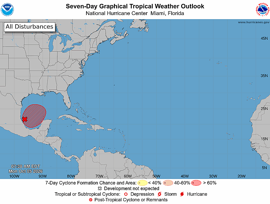
TAMPA — A tropical depression is now likely to form in the Gulf later this week, the National Hurricane Center said Monday morning, while a stalled cold front sets up several days of heavy rain across Tampa Bay before the system ever takes shape.
In its 8 a.m. tropical weather outlook, the hurricane center said a trough of low pressure in the southwestern Gulf is producing disorganized showers and thunderstorms. Conditions appear “marginally conducive,” forecasters wrote, but “gradual development is becoming more likely, and a tropical depression is likely to form during the middle or latter portion of the week.”
The odds jumped overnight. The hurricane center now gives the system a 30% chance of forming within 48 hours and a 70% chance within seven days, up from 0% and 40% on Sunday evening, WUSF reported. The system is expected to drift east over the next few days before turning north.
Where it could go
It is too early to say whether the system will affect Tampa Bay directly. No storm has formed yet, and without a well-defined center, computer models can’t pin down a track with much confidence, according to WUSF.
Models show the low moving toward the northern Gulf Coast later in the weekend, FOX 13 reported, but they disagree on how strong or organized it will be. Strong wind shear, which forecasters tie to this year’s El Niño, could tear the system apart before it gets going.
If it does develop, it would break an unusually quiet stretch. The Atlantic season reached October without a single hurricane, a first in the satellite era, according to the Tampa Bay Times.
The bigger local story this week: rain
For now, the more immediate concern around the bay is flooding. A slow-moving cold front pushing into north Florida on Monday is expected to reach the Tampa Bay area by late Tuesday and stall over Central Florida on Wednesday, according to the National Weather Service in Ruskin.
Deep tropical moisture pooling along that front will keep the week cloudy and wet. Forecasters expect 2 to 4 inches of rain over five days, with “locally higher amounts leading to flooding” possible. Tampa’s rain chance sits around 50% Monday and climbs to 90% Tuesday, according to the weather service’s point forecast. Highs should drop into the low to mid 80s Wednesday through Friday under the clouds.
Boaters should also pay attention. Winds behind the front will turn northeast and east and strengthen, and the weather service expects small craft advisory or exercise caution conditions from late Tuesday through the rest of the week, mainly for Gulf waters from Tampa Bay north.
As of Monday morning, there were no watches or warnings for the Tampa Bay area. Storm chances should ease somewhat over the weekend as the front retreats north, though scattered to numerous storms are still expected each day.
Now is a good time to clear storm drains and gutters, check that your phone is set to receive emergency alerts, and keep an eye on the hurricane center’s outlook as the week goes on.