

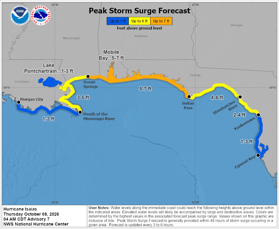
TAMPA — Hurricane Isaias is still forecast to come ashore hundreds of miles from Tampa Bay, but it is now close enough to push water into the bay area’s coastline. The National Weather Service has issued a coastal flood advisory from Citrus County south through Pinellas and coastal Hillsborough for Friday into Saturday morning, with tides running 1 to 3 feet above normal.
That comes on top of a Flood Watch for Thursday, as the same stalled front that has soaked the region all week brings another round of heavy rain.
Where Isaias is now
Isaias became the first hurricane of the Atlantic season Wednesday night. As of the National Hurricane Center’s 8 a.m. ET advisory Thursday, it had sustained winds of 80 mph and was about 175 miles north-northwest of Progreso, Mexico, moving east-northeast at 9 mph. Hurricane hunters were flying into the storm, and forecasters expect it to keep strengthening through early Friday.
The forecast calls for Isaias to turn northeast later Thursday and north on Friday, then make landfall late Friday or early Saturday. A hurricane warning runs from Ocean Springs, Mississippi, to the Bay/Gulf county line in the Florida Panhandle. A storm surge warning stretches from the mouth of the Mississippi River to the Steinhatchee River, and a storm surge watch continues south to Yankeetown in Levy County.
Isaias formed one day short of tying a 121-year-old record for the latest first hurricane of an Atlantic season, according to the Associated Press. That record dates to 1905, when the first hurricane formed on Oct. 8.
What it means for Tampa Bay
Yesterday the main local worries were rain and rip currents. The new piece is water along the coast. The hurricane center’s peak storm surge forecast shows 1 to 3 feet from Yankeetown down to Egmont Key at the mouth of Tampa Bay, assuming the peak surge lines up with high tide. Farther north, the forecast climbs to 2 to 4 feet between Yankeetown and the Steinhatchee River.
The National Weather Service in Ruskin said the coastal flood advisory runs from 8 a.m. Friday to 8 a.m. Saturday for coastal Citrus, Hernando, Pasco and Hillsborough counties and all of Pinellas. Forecasters said Thursday morning that coastal flooding of 1 to 3 feet is possible from Levy County south into Hillsborough, with 2 to 4 feet possible in Levy.
Thursday’s Flood Watch covers Manatee, Hillsborough, Pinellas, Pasco, Hernando, Citrus and Sumter counties through the evening. Ground across the region is already saturated, and the weather service expects another 1 to 3 inches of rain in many spots, with 5 inches or more where storms keep training over the same area. The heaviest rain was expected around St. Petersburg and Tampa during the morning and early afternoon before shifting north toward the Nature Coast.
On Friday, winds turn southeast as Isaias moves north. Showers and storms should move faster, lowering the risk of widespread flooding rain but raising the chance of strong gusts. Large swells from the hurricane are expected to reach the coastal waters late Thursday night, with seas of 6 to 10 feet and dangerous rip currents at area beaches Friday and Saturday. Small craft conditions on the Gulf are expected to be hazardous.
More showers and storms are likely Sunday before drier air arrives early next week.
Fuel and cruises
Isaias is also being felt in ways that have nothing to do with the forecast cone. Producers have shut in about a quarter of Gulf oil production, roughly 511,000 barrels a day, ahead of the storm, the Associated Press reported. Florida has no crude oil refineries or interstate fuel pipelines and depends on fuel arriving by ship, and more than 45% of the state’s petroleum moves through Port Tampa Bay, FOX 13 reported.
Officials have not said how long the shutdown will last or whether Isaias will disrupt fuel shipments to Florida beyond a few days. A longer disruption could put more pressure on fuel prices.
Cruise passengers sailing from Tampa this weekend should watch for itinerary changes. Ships can steer around storms and buy fuel at other ports along the way, cruise industry expert Stewart Chiron told FOX 13. “The beauty of the cruises is they’re not stationary,” Chiron said. “They can be moved in order to avoid inclement weather.” His advice for passengers: “What people need to be doing is constantly looking at the cruise lines’ websites because they will provide updates.”
Airlines including American, Delta and United have issued travel waivers for Friday and Saturday flights through Pensacola, Mobile, Destin-Fort Walton Beach, Gulfport-Biloxi and New Orleans. Travelers flying from Tampa International to those cities should check with their airline about rebooking without change fees.
What to do
Avoid driving through flooded streets. If you live on the water in Pinellas or along the Hillsborough, Pasco or Hernando coast, move cars and anything you care about off the ground before Friday’s high tides. Stay out of the Gulf Friday and Saturday. Anyone planning a weekend drive to the Panhandle or Alabama coast should watch the forecast closely. Preparedness checklists are at FloridaDisaster.org.
TBO first reported on Isaias when it formed Wednesday. We’ll update as forecasts change.