

These dirsturbances are no longer active.
Aug. 12 at 1 p.m.
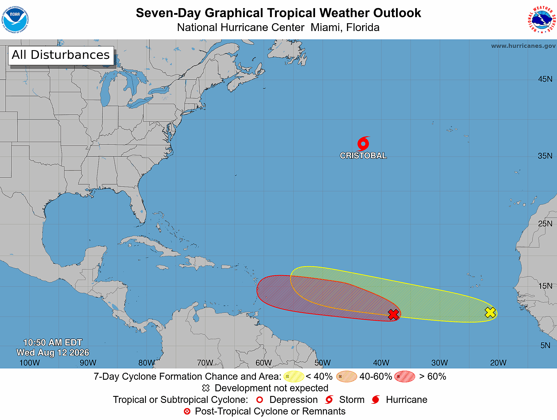
Overnight, the Atlantic became more active as a previous disturbance strengthened into Tropical Storm Cristobal.
The National Hurricane Center (NHC) said Cristobal will continue moving east. The storm has sustained winds of 45 mph and is moving east at 25 mph.
Disturbance 1 has increased to an 80% chance of cyclone development over the next seven days. NHC said Disturbance 1 has active showers and thunderstorms and is currently associated with an area of low pressure about 900 miles west-southwest of the Cabo Verde Islands.
The system is expected to become a tropical depression within the next couple of days as it continues moving westward to west-northwestward across the central tropical Atlantic.
A new development has formed in the Eastern Tropical Atlantic behind Disturbance 1. NHC said a tropical wave offshore of the coast of West Africa is producing disorganized showers and thunderstorms.
The system is expected to become more conducive for development over the next several days as it moves westward or west-northwestward across the eastern and central Tropical Atlantic.
Aug. 11 at 9 a.m.
There are two disturbances in the Atlantic, with Disturbance 1 increasing to a 70% chance of cyclone formation in the next seven days and a 30% chance of development in the next 48 hours.
NHC said Disturbance 1 has active showers and thunderstorms and is currently associated with an area of low pressure about 500 miles southwest of the Cabo Verde Islands.
The NHC said environmental conditions are expected to become more favorable for development during the next couple of days, with a tropical depression potentially forming during the latter half of the week. The system is moving westward to west-northwestward across the central tropical Atlantic.
Disturbance 2 has dissipated and has a 0% chance of development.
Disturbance 3 remains at a 10% chance of development in the next several days as it moves eastward at about 20 mph across the central subtropical Atlantic. As it continues to move, it will reach cooler waters, which the NHC said are expected to weaken the disturbance and reduce its chance of formation by Thursday.
Aug. 10 at 10 a.m.
Over the weekend, three disturbances formed in the Atlantic, and the NHC is tracking all three systems.
Disturbance 1 is in the eastern and central tropical Atlantic and has a 60% chance of tropical cyclone formation within the next seven days. The NHC said the area of low pressure is located a few hundred miles south of the Cabo Verde Islands. The system is moving slowly westward, and the NHC said a tropical wave over West Africa is expected to merge with the disturbance in the coming days. A tropical depression could form during the latter half of the week as the system moves westward to west-northwest.
Disturbance 2 is in the central tropical Atlantic and has a 10% chance of formation within the next seven days. The disturbance and an associated tropical wave are located midway between the coast of West Africa and the Lesser Antilles. The NHC said the system has some potential for development during the middle of the week as it moves quickly westward across the central tropical Atlantic.
Disturbance 3 is in the western subtropical Atlantic and has a 10% chance of formation within the next seven days. The NHC said the area of low pressure is located a few hundred miles northwest of Bermuda. As the system moves into cooler waters, the NHC said conditions are expected to become unfavorable for further development.
Disturbance 1 has a 20% chance of formation within the next 48 hours, while disturbances 2 and 3 each have a 10% chance of formation.
The Tampa Bay Observer will continue monitoring NHC forecasts for the three disturbances and provide updates as conditions develop.