

July 20, 8:08 p.m.
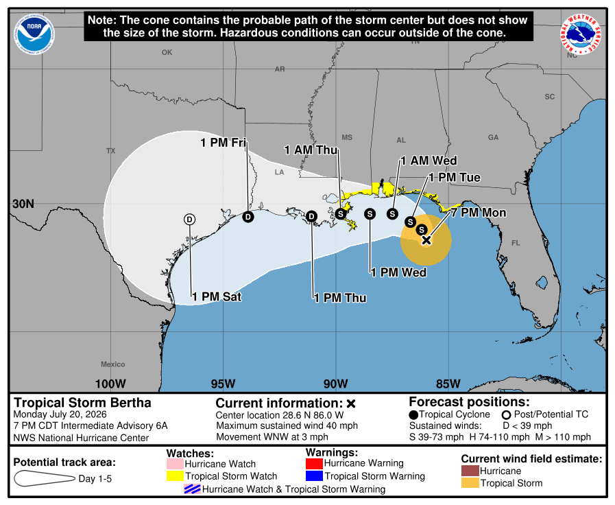
Tropical Depression 2 has strengthened into Tropical Storm Bertha, according to the National Hurricane Center (NHC).
Bertha is moving west-northwest at 3 mph with maximum sustained winds of 40 mph. A storm surge watch is in effect along the Alabama-Florida border, the Mississippi coast and southeastern Louisiana coast.
The NHC said life-threatening storm surge is possible in the watch area.
Flash flooding is also possible through Friday along the Gulf Coast and across island locations from western Florida north of Fort Myers to the middle Texas coast.
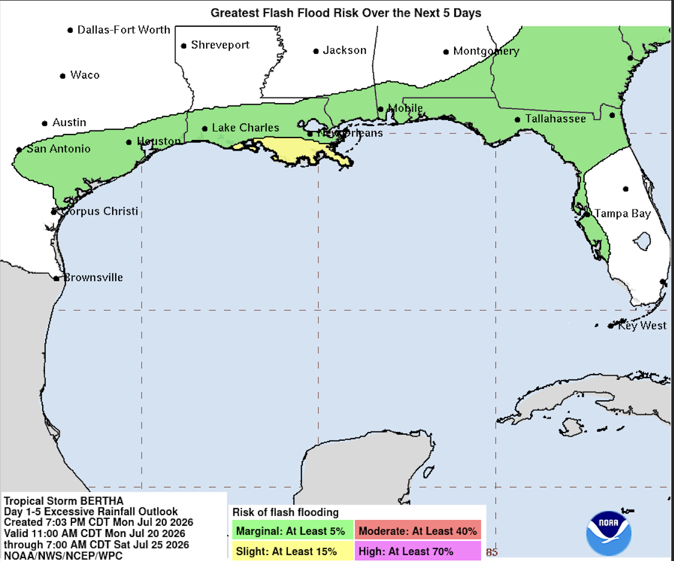
Tropical storm conditions are possible in the Florida Panhandle by late Monday night into Tuesday. Bertha is expected to bring rainfall totals of 2 to 4 inches, with isolated areas receiving up to 8 inches.
Residents along the Gulf Coast are encouraged to monitor updates from the National Hurricane Center as the storm moves west-northwest.
July 19, 12:53 p.m.
The area of low pressure over the northern Gulf of America near Florida has strengthened into Tropical Depression 2, the National Hurricane Center announced Sunday.
NHC latest advisory said Tropical Depression 2 has maximum sustained winds of 20 mph and is moving north-northwest at 2 mph.
A Tropical Storm Watch has been issued for parts of the Florida Panhandle as the system continues to organize. NHC said interests along the Gulf Coast, including Alabama, Mississippi, Louisiana and Texas, should continue monitoring the storm's progress.
Heavy rainfall is expected and NHC said flash flooding will be possible through Thursday along portions of the eastern and central Gulf Coast, from western Florida to southern Alabama, Mississippi and Louisiana.
July 19, 10:07 a.m.
The NHC is tracking an area of low pressure over the northern Gulf of America near Florida that has become significantly more likely to develop into a tropical cyclone. The system's chance of formation has increased from 40% to 80% over the next 48 hours and seven days.
As the disturbance becomes better organized, shower and thunderstorm activity continues to increase.
Forecasters expect a tropical depression to form later today or Monday as the system moves slowly northward or northwestward.
NHC said residents along the northern Gulf Coast, including Florida, Alabama, Mississippi and Louisiana, should closely monitor the system, as tropical storm watches or warnings could be issued later today.
July 18, 2:21 p.m.
The disturbance off Florida’s Gulf Coast now has a 40% chance of developing into a tropical cyclone within the next seven days, according to the National Hurricane Center.
The NHC said surface observations indicate a broad area of low pressure is forming over the eastern Gulf of America. Winds remain light, but showers and thunderstorms associated with the system are still disorganized.
Slow development is possible as the system moves slowly northward or north-northwestward over the next few days and could become a tropical depression.
Residents along the Florida Gulf Coast, southern Alabama and southwestern Georgia are encouraged to monitor the system, as it could bring periods of heavy rainfall.
The system has a 30% chance of tropical cyclone formation within the next 48 hours.
July 18, 9:41 a.m.
The disturbance off Florida's Gulf Coast has moved into the northern Gulf of America near Florida, with a low chance of tropical development over the next week.
The National Hurricane Center (NHC) said surface observations indicate pressure remains high across the area and winds are light. However, slow development is possible as the system moves northward or north-northwestward over the next several days.
Residents along Florida's West Coast and the Florida Panhandle should continue monitoring the system, as the NHC said it is expected to bring heavy rainfall to portions of the region over the next several days.
The disturbance now has a 30% chance of cyclone formation within the next seven days.
July 16, 8:30 a.m.
The National Hurricane Center (NHC) is monitoring a second disturbance in the Atlantic.
The eastern tropical disturbance is producing disorganized showers and thunderstorms associated with a tropical wave located southeast of the Cabo Verde Islands.
Slow development is possible over the next day or two as the system moves west-northwest at about 10 mph. However, the National Hurricane Center said the disturbance is expected to move into a less favorable environment over the weekend, limiting any additional development.
Meanwhile, the disturbance off Florida's Gulf Coast remains at a 20% chance of tropical cyclone development over the next seven days. The National Hurricane Center said an area of low pressure is expected to form over the northeastern Gulf this weekend.
July 15, 9 a.m.
The National Hurricane Center (NHC) is monitoring a disturbance off Florida's Gulf Coast that could develop over the northeastern Gulf this weekend.
According to NHC, slow development is possible as the system drifts northeastward across the northeastern Gulf and toward or near the southeastern U.S. coast early next week.
The disturbance has a near 0% chance of development over the next 48 hours and a 20% chance of development over the next seven days.
The Tampa Bay Observer will continue tracking the disturbance and provide updates as more information becomes available.