
June 17, 11:08 a.m.
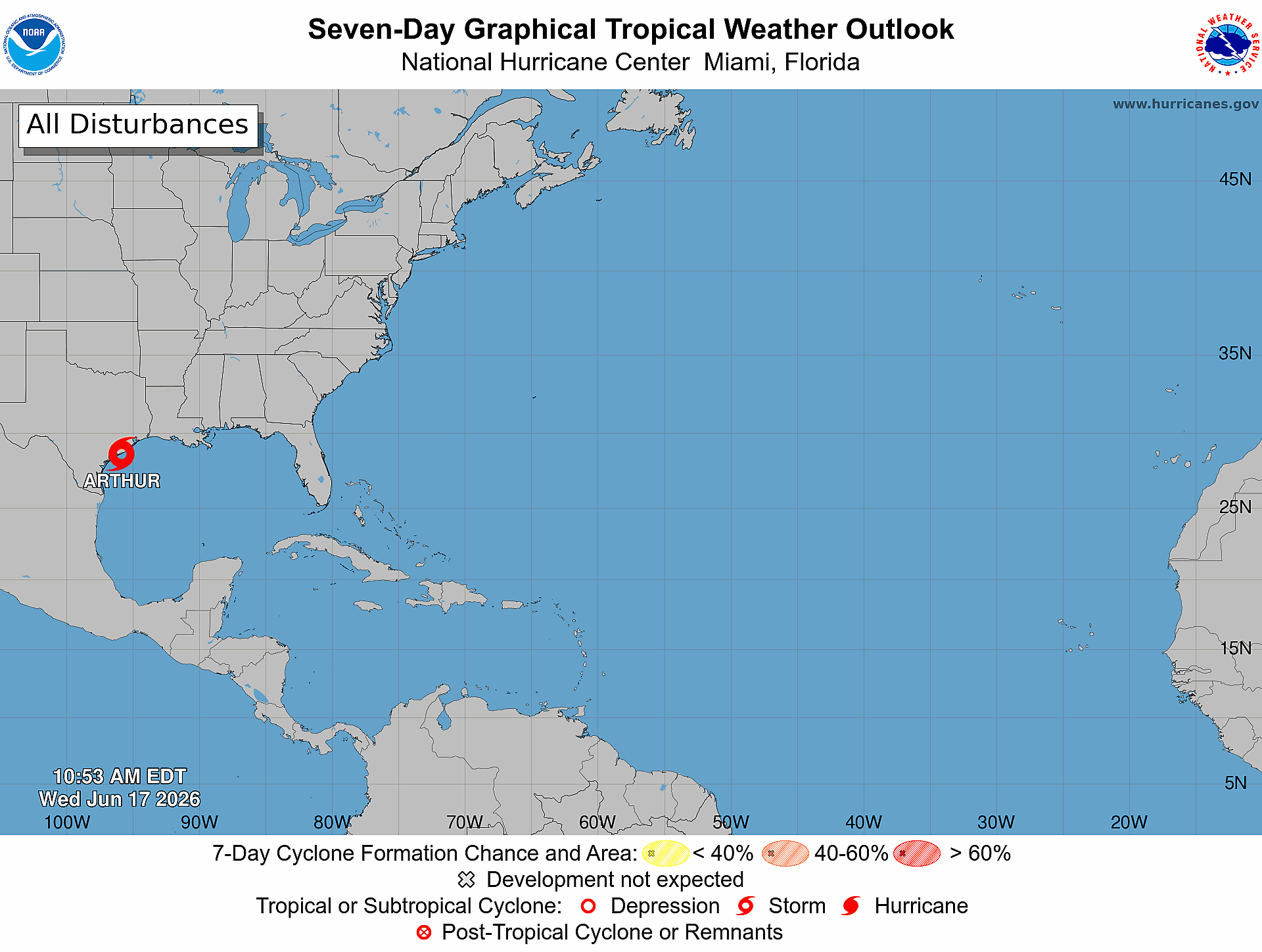
Potential Tropical Cyclone One is now the first name Atlantic storm of the season. Tropical Storm Arthur is moving North East at 9 mph.
National Hurricane Center said Arthur is about 40 miles of Port O'Connor Texas with maximum wind speed of 40 mph.
Tropical Storm Warning is in effect for High Islands, Texas to Morgan City, Louisiana.
June 17, 8:34 a.m.
National Hurricane Center said Potential Tropical Cyclone One will most likely form into a tropical storm today.
The system is moving toward the northeast at 7 mph and is expected to increase today. NHC said the maximum sustained winds will be near 30 mph.
June 16, 2:26 p.m.
The broad area of low-pressure has developed into Potential Tropical Cyclone One and is forecast to strengthen into a tropical storm as it moves along the northwestern Gulf Coast through Wednesday, according to the National Hurricane Center.
Tropical Storm Watches have been issued from Sargent, Texas to Morgan City, Louisiana.
NHC issued advisories for the system and warned that potentially life-threatening flash and urban flooding are possible along the Texas coast and into central Mississippi through Thursday.
The cyclone is currently moving west at 6 mph with maximum sustained winds of 30 mph.
June 14, 12:09 p.m.
The broad area of low-pressure is now a 20% chance of formation over the next seven days. The National Hurricane Center said the low pressure is over eastern Mexico producing disorganized showers and thunderstorm activity.
NHC predicts no development over the next day or so while the low-pressure is inland over northeastern Mexico or southern Texas during the next day.
The system could re-emerge over the northwestern Gulf of Mexico around midweek while interacting with a frontal boundary. NHC said conditions are expected to have limited development.
June 12, 9:58 a.m.
A broad area of low-pressure has formed over the southern Bay of Campeche and is creating showers and thunderstorms in the area. The National Hurricane Center said the system could see limited development before moving inland over eastern Mexico late Saturday or Sunday.
NHC said the system could re-emerge over the northwestern Gulf on Tuesday and Wednesday while interactive with a frontal boundary. If this does happen there will be limited development.
The disturbance is still at a 10% chance of cyclone formation through the next seven day.
June 11, 12:34 p.m.
The low-pressure disturbance around Bay of Campeche is still at a 10% chance of formation over the enxt seven days according to the, National Hurricane Center (NHC).
However, NHC did add that there is a 10% of formation in the next 48 hours. On Friday, the low-pressure is predicted to form and move westward from a tropical wave currently located over Yucatan Peninsula of Mexico.
The system is expected to move inland over eastern Mexico late Saturday or Sunday.
June 10, 9:51 a.m.
NHC marked its first low-pressure disturbance of the Atlantic hurricane season Wednesday, June 10 at 8 a.m.
According to the NHC, the disturbance could develop into a tropical cyclone over the Bay of Campeche later this week. However, conditions are not expected to be significant, and the system is forecast to move inland over eastern Mexico later this weekend.
The disturbance currently has a 10% chance of development over the next seven days.
The Tampa Bay Observer will continue tracking this system and provide updates as more information becomes available.